A contour survey is a detailed map that illustrates the shape and elevation of the land by using contour lines to represent different heights. Surveyors use specialised equipment such as GPS, total stations, and laser scanners to capture accurate data about the land’s surface. This data is then processed to create a map that highlights variations in height and slope, which is essential for planning and development.
Why is a Contour Survey Important?
Contour surveys are crucial in various stages of development and construction. They help:
- Ensure proper planning and design – Prevents costly errors by identifying potential issues before construction begins.
- Identify drainage and soil stability risks – Allows for effective water management and foundation planning.
- Provide data for landscaping and infrastructure – Ensures designs align with the natural features of the land.
Key Features Shown in a Contour Survey
Land Elevations and Slopes
A contour survey highlights the natural variations in land height, showing where the land rises and falls. This information is crucial for:
- Determining high and low points that may affect drainage or construction.
- Planning building foundations, retaining walls, and grading work.
- Designing structures that fit seamlessly into the natural landscape.
Natural and Man-Made Features
Contour surveys identify both natural and artificial features on the land. These include:
- Natural features: Trees, rocks, creeks, and other environmental elements.
- Man-made features: Existing buildings, fences, retaining walls, and drainage systems.
Knowing these details allows developers to design projects that preserve important features and avoid interference with existing structures.
Drainage Patterns and Water Flow
Water management is a key consideration in any construction project. A contour survey shows how water naturally flows across the land, helping to:
- Identify areas prone to water accumulation.
- Design effective drainage systems to prevent flooding and erosion.
- Plan landscaping projects that align with natural water flow patterns.
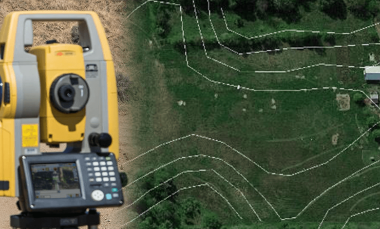
Contour Lines and Gradient
Contour lines indicate changes in elevation and slope across the property. The spacing of these lines provides insight into the gradient of the land:
- Closely spaced lines: Indicate steep slopes or rapid changes in elevation.
- Widely spaced lines: Suggest gentle slopes or relatively flat terrain.
Understanding gradient data helps determine the feasibility of construction projects and earthworks.
Low and High Points
Contour surveys pinpoint the highest and lowest points on the property, which is critical for:
- Grading and levelling land before construction.
- Assessing flood risks and designing drainage solutions.
- Determining the best locations for structures and landscaping features.
When Do You Need a Contour Survey?
Contour surveys are necessary in various situations, including:
- Before designing a new building or extension – Ensures the structure fits the natural slope and avoids potential drainage issues.
- When planning landscaping or drainage projects – Provides critical data for grading and water management.
- For land subdivision and development – Helps determine the feasibility of new lots and infrastructure.
- Prior to purchasing land – Allows buyers to assess potential challenges and development opportunities.
How to Interpret a Contour Survey Report
Understanding a contour survey involves recognising the significance of contour lines and elevation data. Some key points to note include:
- Contour line spacing: Indicates slope steepness; closer lines mean steeper slopes.
- High and low points: Show where water may accumulate and where grading adjustments may be needed.
- Natural and man-made features: Help assess the land’s suitability for different types of development.
Read also: Why Every Business Needs Professional SEO Services to Succeed
Bottom Line
A contour survey provides valuable insights into land elevation, natural features, drainage patterns, and slope gradients. This information helps architects, engineers, and developers make informed decisions about site preparation and construction. Whether you’re planning a new building, landscaping project, or land subdivision, a contour survey ensures that your project is based on accurate and reliable data.